
An Update on the Lindbergh Intermodal Transportation Center (ITC) Option
By Carl Nettleton
The San Diego Association of Government’s (SANDAG) leadership in developing a proposed Grand Central Station to link San Diego International Airport with regional ground transportation modes is an important initiative whose time is long overdue. The options for the Grand Central Station concept have been reduced to the Navy’s SPAWAR facility and a location called the Intermodal Transportation Center, both between Interstate 5 and Pacific Highway. Whichever site is chosen could significantly help in unifying the region’s transportation modes and meeting the City of San Diego’s climate goals.
As is always the case with large scale San Diego projects, funding will be a challenge. But there are other obstacles that need to be addressed early in the process to be successful. How do I know? When San Diego faced a critical decision about the future of its only major commercial airport in 2007/2008, I was fortunate to have managed a team of professionals, on behalf of the Independent Voter Project, analyzing the possibility of moving Lindbergh Field’s terminals to the Pacific Highway side of the runway and creating a Grand Central Station adjacent to the airport’s property. We called it the Lindbergh Intermodal Transportation Center (ITC), and it is one of the two sites SANDAG has chosen to consider.
San Diego has one of the best run airports in the country. It is adjacent to downtown where the bulk of the city’s business and government communities operate. It is also in the heart of the ocean-based tourism industry with hotels and ocean-related recreation almost within walking distance of Lindbergh Field. It is convenient, easy to navigate, and the perfect amenity for San Diego’s economy.
The problem isn’t this very handy airport. The problem is how transportation connects to the airport and the impact of those poor transportation linkages on the adjacent communities. Our goal in sharing the ITC concept was to suggest a fix to that problem and to do the heavy lifting of showing how it would work.
To illustrate, Lindbergh Field’s terminals are on the south side of the runway and all of the transportation link are on the north side. How convenient to have two train lines, the Coaster (serving the coastal area from downtown to the north) and the Pacific Surfliner, (a link to Los Angeles’ Union Station and points beyond) that pass in view of the airport. How convenient to have the light rail system, the San Diego Trolley (serving communities miles to the east and all the way to the Mexican border), to have a stop across Pacific Highway from the runway. How convenient to have Interstate 5 looking down on the runway.
How inconvenient to be required to ride on surface streets to each the airport’s terminals from those transportation modes. Those streets include Harbor Drive, a boulevard which should be a scenic San Diego thoroughfare but fails in that regard because of airport-related traffic congestion. Other roads, including Grape and Hawthorn streets are heavily impacted as vehicles go to and come from the airport.
The single biggest and recurring community lament about the airport has for decades been that it did not connect with the region’s light rail system. “Why doesn’t the trolley have a line that goes to the airport?” people have lamented.
We asked a different question. We asked, “why doesn’t the airport link with all of the San Diego transportation networks that would be a stone’s throw away if the terminals were on the north side.” Our design was intended to not only address the realities of the airport’s future growth, but to link all of San Diego’s transportation networks, take traffic off Harbor Drive, Grape and Hawthorn streets, and even Rosecrans Street while contributing to the reduction of transportation-based emissions in the region.
Our answer was the Lindbergh Intermodal Transportation Center (ITC) which we first imagined in the simplest format below:
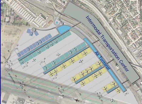
Image from Lindbergh ITC project materials
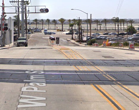
This image helps to imagine the benefit of the Intermodal Transportation Center. Taken from the street adjacent to the Palm Street Trolley Station, Lindbergh’s runways are only a half a block away. Image courtesy of Google Street View
To allow a broader range of community leaders to understand the concept, we hired Focus 360, one of the early innovators in building information modeling (BIM). We asked the firm to create a virtual model of our concept, using the existing Terminal 2 design but placing it adjacent to Pacific Highway north of the existing runways. To ensure accuracy, Focus 360 utilized onsite GPS to model the placement of the building and the existing roadways to 6-inch accuracy. The results are summarized below.
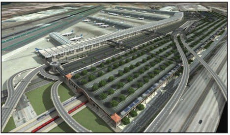
Image from Lindbergh ITC project material
The Lindbergh Intermodal Transportation Center concept seen above, resulted from the work of international transportation planners hired to create predictions for traffic and transit use, sustainability experts to identify the impacts of greenhouse gases, criteria air pollutants, and options for building a truly green facility, consultants using GPS to develop accurate elevations for each roadway on the north side, and architectural communications specialists to create renderings.
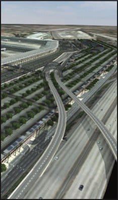
Image from Lindbergh ITC project materials
To make the best use of existing infrastructure, the Pacific Highway off-ramp was imagined as a primary access route from and to the south. It would have dropped into the airport loop and split off to continue on its existing path
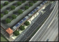
Image from Lindbergh ITC project materials
Kettner Boulevard would be expanded to four lanes, and long-term parking and rental car return would be accessed from this existing street
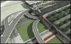
Image from Lindbergh ITC project materials
A loop system brings vehicles around both the train/trolley and airport portions of the ITC, with a ramp heading to I-5 South on the far left
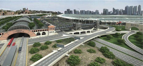
Image from Lindbergh ITC project materials
This view from the north shows the multiple rail systems entering the Lindbergh ITC. On the right would be a grand entrance to MCRD, giving the base the visual recognition it deserves. The terminals are on the right just above the MCRD entrance with the city skyline in the background. Short term parking would be in the area between the ITC and the terminals and could be used by both air passengers and local commuters. An offramp from I-5 would connect directly to the terminal.
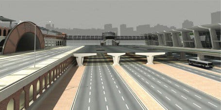
Image from Lindbergh ITC project materials
This cutaway of a section of the ITC shows Pacific Highway, with four lanes each way, running underneath the short-term parking area. On the right, the air passenger pickup level is above and the drop-off level is below. Dedicated bus lanes in both directions would add another transit option or room to expand air passenger operations. On the left, the arch of San Diego’s new train station would welcome passengers being dropped off on the train/trolley side of the ITC loop. Trolleys would stop in front of each of the skybridges which lead to individual piers for airplanes. This image also shows the multiple levels of long-term parking.
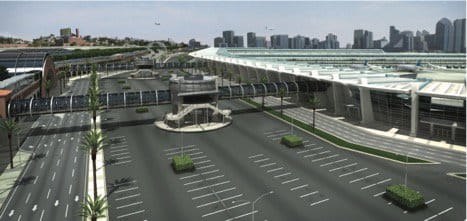
Image from Lindbergh ITC project materials
Between the airport terminals on the right and the ITC on the left, a 2,000-space parking lot provides convenient access for “kiss and fly” travelers at the passenger pickup level. Rail passengers would be picked up and dropped off on the left side of the loop. A skybridge takes passengers across the short-term parking area to link air with rail, rental car, taxi, shuttle, and other ground transportation found inside the structure. A loop system brings vehicles around both the train/trolley and airport.
The work product benefited from consultations with a number of public organizations, including SANDAG, the Metropolitan Transit System, North County Transit District, Port of San Diego, City of San Diego, Caltrans, the Federal Aviation Administration, the United States Marine Corps, the U.S. Department of Transportation, and California Department of Transportation’s Aeronautical Division. We wanted to learn about the challenges that would be faced by those agencies.
Every effort was made to develop information consistent with airport transportation data and the information presented in the 2008 Airport Master Plan, the associated Draft Environmental Impact Report, and airport forecast documents. The goal was to provide a fair assessment of the possibilities and to make sure that, in the public’s interest, the possibilities presented in the Lindbergh ITC concept would not be lost forever.
The Lindbergh Intermodal Transportation Center proposed a unified transportation solution that promised to help maintain San Diego’s valuable quality of life by reducing traffic, increasing transit use, and making San Diego a more sustainable region by being on the forefront of innovation in transportation, emissions, and community planning.
The purpose of this story is to help readers understand the challenges we learned about in offering our proposal as a public option, the opportunities that still exist, and those that have been lost. It seems important that what we learned from our project be shared with planners, decision makers and the public. After all, it was called “The Lindbergh Intermodal Transportation Center - A Fast -Track Solution to Unifying San Diego’s Transportation Options.”
I was hired by the Independent Voter Project to manage the overall project and conduct a situational analysis. Our work included:
- A $200,000 sustainability report that compared the option we proposed and those in the San Diego International Airport’s Master Plan,
- A $20,000 virtual model of the proposal, using the existing Terminal 2 design, with roadways and buildings calibrated to six-inch precision using GPS technology,
- An analysis of airport-adjacent land use,
- A series of presentations and listening sessions with all of the region’s transportation-related agencies and other stakeholders, and
- Understanding how the San Diego Unified Port District’s uses and airport uses of waterfront properties affected each other.
In total, this private initiative spent more than $300,000 to present an option for the region to consider.
What was the proposal? In short, we showed how the airport could connect with the trolley and all the other transportation modes by moving the terminals to the north side of the runway, adjacent to Pacific Highway. These elements resulted from our research:
- There was room on the Pacific Highway side of the runway to build terminals and airplane parking sufficient to maximize the capacity of Lindbergh Field’s single runway.
- Much of the land use between Pacific Highway and Kettner Blvd. (just below I-5) was already used for airport-related uses, including private parking and rental cars. Much of the remaining property was held by public agencies or San Diego Gas & Electric. This property could be repurposed to create the Lindbergh ITC.
- The Lindbergh ITC would contain all parking, rental cars, trolley, train, a people mover and even, if built, high-speed rail connections. Every transportation option, including the adjacent I-5, could connect to the ITC. Short-term parking would be built over Pacific Highway, and one could walk a short distance over Pacific Highway from ground transportation to the terminals.
- An underutilized Pacific Highway could be used as an airport thoroughfare, integrated into the terminal traffic pattern, with those leaving the airport to the south heading into downtown through a tree-lined Pacific Highway gateway – Welcome to San Diego!
It should be noted as mentioned above, that in this 2007-2008 timeframe, the airport was completing its new master plan and the environmental review process for that plan. Terminal One needed to be replaced. Terminal Two needed to be expanded in size. The decision point was at hand over whether to invest billions of dollars in keeping the terminals on the south side of the runway or to be part of a regional transportation solution by moving them to the north side of the runway.
As we described it in our summary document, “The real question is this: how much investment and how much congestion are we willing to tolerate until we are forced to confront the reality that this is our only practical option?”
The benefits of our proposal were multiple.
- If you wanted to use public transportation, every form of public and private transportation would link at the Lindbergh ITC. You could get to the airport by train from North County, by trolley from east county and south county (and soon from the north to University City). This would not just benefit the airport, but those commuting almost anywhere in San Diego because you could transfer from the train to the trolley or vice-versa. Rental cars would be available without needing to shuttle. Bus routes would focus on the ITC.
- A major part of the work included the study and report we commissioned, the San Diego International Airport Expansion Sustainability Analysis, which showed the following:
- Improved reduction in carbon emissions over all other airport expansion options in the master plan.
- Traffic from downtown to Point Loma would be significantly reduced. The airport’s preferred alternative expanded Harbor Drive to ten lanes and continued to use Harbor Drive, Grape Street, Hawthorne Street, Nimitz Blvd. and Rosecrans Street as congested, quasi-airport roads. The Lindbergh ITC dramatically improved those thoroughfares because airport traffic would no longer use them. In particular, Harbor Drive would become a beautiful roadway focused on adjacent views of the bay rather than congestion, and Rosecrans would be returned to local residential and commercial usage, although still congested.
- Airport employee and rental car parking would be removed from Harbor Island and located in the Lindbergh ITC footprint, where both employees and travelers could get to work and their planes without needing shuttles.
- The Marine Corps Recruit Depot could have a grand new entrance.
The work we did was presented at a joint meeting of the boards of directors of both SANDAG and the San Diego County Airport Authority on February 8, 2008. As a result of that presentation and the work presented, an Ad Hoc Airport Regional Policy Committee, chaired by San Diego Mayor Sanders, was convened, meeting every other Saturday to determine the future of airport expansion. Called Destination Lindbergh this was “a year-long, comprehensive planning process designed to: (1) determine the ultimate build-out configuration of San Diego International Airport at Lindbergh Field (SDIA or the Airport), (2) evaluate and plan to minimize airport-related traffic impacts to adjacent communities, and (3) improve intermodal access to the Airport, while considering the Airport as a potential location for a regional transportation hub.” (From Destination Lindbergh)
The Destination Lindbergh policy committee was informed by the work of a $5 million study paid for by the Airport Authority. This convening was likely the largest public policy leadership group of its kind in San Diego, in both leadership time commitment and representation. Called a “breakthrough alliance” in the final report, the committee was formed by the San Diego County Regional Airport Authority (the Authority), the City of San Diego (the City) and San Diego Association of Governments (SANDAG). The Ad Hoc Committee also included policy makers from the Unified Port of San Diego, County of San Diego, Metropolitan Transit System, North County Transit District and U.S. Department of Defense.
The Destination Lindbergh final report included our proposal (called Option B1) and three other short list options. NOTE: The link is to the executive summary within SANDAG’s 2050 Regional Transportation Plan. The full report does not appear to be available online.
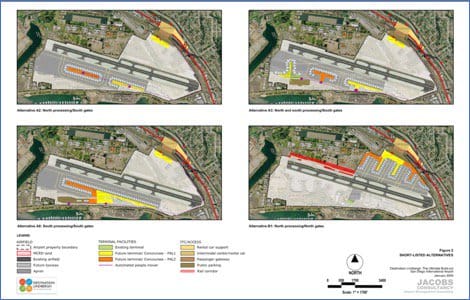
Image from Destination Lindbergh Executive Summary
- Alternative A2 processed all passengers on the north side of the runway but kept the gates on the south.
- Alternative A3 had processing of passengers on both the north and the south with gates on the south.
- Alternative A8 had south processing and south gates.
- Alternative B1 (our proposal) had processing and terminals all on the north.
Our alternative was essentially as cost effective as the others. Alternative A2 was chosen as the preferred option and was estimated to cost $5.8-$7.9 billion. Our Alternative B1 would cost $6.1-$8.3 billion. Not to diminish the $200-$300 million difference, for a project of that size, B1 was clearly in the same ballpark and with transportation, community and environmental benefits that surpassed all the other options.
Alternative A2 is the option that still exists as possible today and has been partially implemented.
Why was Alternative B1 not preferred? It was blocked by one key factor: to build the terminals on the Pacific Highway of the side of the runway required a 150 foot strip of Marine Corps Recruit Depot land (27 acres) to extend Taxiway C. Taxiway C did not extend the full length of the runway, meaning airplanes landing from the east would have to turn left off the runway and then cross the runway to reach the gates, a process that reduced the maximum number of flights the airport could handle and raised safety concerns. Interestingly, the MCRD property had no buildings on it, but consisted of recreational and training exercise facilities. It would have required realigning a sports field and running track. While this might seem unrelated to the current Grand Central Station proposal, it is included here because indicative of the kind of obstacles that have to be identified early if the project is to become a reality. We never anticipated that something as simple as a 150-foot-wide strip of government owned land would be enough to stop a regionally beneficial solution.
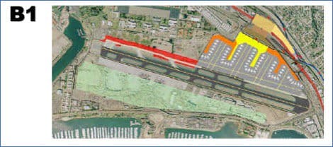
Image from SANDAG, Destination Lindbergh
In the image above from a Destination Lindbergh presentation, the area in red had to be obtained from the Marine Corps Recruit Depot to allow airplanes landing from the east to turn to the right off the runway to reach the terminals. Turning left would mean crossing the runway to reach the terminals, a safety and efficiency issue.
Opinions then and since have differed as to why a 150-foot strip of land couldn’t be obtained from the Marine Corps, especially since incoming recruits could be marched directly from their planes to MCRD if the terminals were on the same side of the runway as the base without needing a bus or shuttle. Explanations ranged from the simple to the political:
- “Marines take land, they don’t give it up,”
- The military has already given up too much land to the region, using the Point Loma Wastewater Treatment Plant and the Miramar Landfill as examples,
- The Base Realignment Process (BRAC) underway at the time was being pressured to give up military land at four different locations in the U.S. Giving up one (i.e. to San Diego’s airport) would set a precedent jeopardizing all.
Here’s what the Marine Corps said in an official letter to Mayor Jerry Sanders who chaired the ad hoc committee:
The Base Realignment and Closure Commission has repeatedly confirmed the validity of our mission, facilities, and location. The City, SANDAG, and the Airport Authority are faced with some challenging decisions. I would like to clarify some issues that may assist in that effort. Over the years, we have willingly given up and allowed the use of excess Marine Corps real estate to support regional demands, including the airport. We have no more excess to give. I know that many of you have heard about a possible land deal which was on the table a number of years ago. That deal was proposed as a swap. It was not consummated, and the Depot land under consideration has since been completely integrated into our training support plans - it is actively being used to train new Marines.Additionally, the land that was proposed to be passed to the Depot in that exchange is the very property that is now being considered for further development by the airport. In short, MCRDSD property is a national defense resource that should not be considered as part of the solution to resolve airport land use issues.
In any case, the alternative to move the airport’s terminal to the Pacific Highway side of the runway was blocked as described in this paragraph from the Destination Lindbergh executive summary:
Alternative B1 Because land is unavailable to extend Taxiway C, this alternative is not feasible in the foreseeable future.
Even though it is too late to build the terminals on the Pacific Highway side of the runway, it is important to know how that proposal was frustrated, and to recognize there is still time to connect the airport and all the other transportation modes in an effective way, whether it is at the SPAWAR site or the ITC site we had suggested. It is not too late to create a transportation hub, adjacent to I-5, that could still take the traffic off Harbor Drive, Grape Street and Hawthorn Street. In fact, Destination Lindbergh’s option A2 suggests that. The rail lines and roads are still there. Pacific Highway could still handle the traffic, and much of the land between Pacific Highway and I-5 is still being used for airport uses. In fact, with the new rental car facility now located on the site where we thought the terminals could be moved, part of the work has already been done. The ITC site we proposed, along with the land currently used by SPAWAR, creates two competing sites with which to compare and contrast the opportunities and bring the Grand Central Station to reality.
A new obstacle to consider is the fact that a parking garage and access has already been built next to Terminal Two with access from Harbor Drive. One of the goals of an intermodal transportation center would be to give travelers quick access to the airport from all modes. To make the ITC as feasible as possible, it is important that the transportation center become the only way to get to the terminals. An ideal solution would be to locate the transportation hub adjacent to the runway on the north side and to create a tunnel with a people mover under the runway.
Unfortunately, human nature dictates the desire to drive as close as possible to the airport terminals.
Because the Terminal 2 parking garage has already been built, it is unlikely that people arriving at the airport will want to give up the convenience of being dropped off curbside or parking at the terminal. In addition, if the decision was made to not use the parking garage in order to force use of a Grand Central Station, two things are likely. First, there would be opposition to stranding those parking assets after so much had been spent building them. Second, passenger demand to use curbside drop off and adjacent parking would change that decision. Returning Harbor Drive to primary use as a city street rather than as an airport access road requires moving personal vehicle traffic to the north side. In addition, there are revenues airport parking provides that could be important to financing the Grand Central Station.
This convenience factor has relevant history. When Terminal Two was expanded, a bridge was built over Airport Terminal Road at the far end of short-term parking, and a fence was built to keep passengers from crossing that road at street level. This meant that passengers going to and from the gates would have to walk to the bridge and then back to their cars instead of crossing the street and going directly to their vehicles. This was done to keep vehicular traffic moving. The requirement to take a circuitous walk to and from the bridge resulted in public demand to remove the fence. This was done, and a traffic light was installed, allowing street level crossings once again. The same kind of pressures would likely happen if curbside drop-offs and parking at the terminal were eliminated by a new Grand Central Station. That choice would soon be restored, reducing the effectiveness of the centralized transportation hub.
Thinking through public reaction to what infrastructure exists and what is being imagined is critical to avoid unintended consequences. The Terminal Two garage was built to accommodate short-term parking needs yet that structure potentially has long-term consequences. Even with a Grand Central Station, there will be significant pressure to continue to allow drivers to reach the terminals directly and to park in the garage rather than through a transportation hub. Will additional parking be built as part of the Terminal One expansion that is currently being planned? It might be wise to revisit that decision given that the majority of air passengers use Terminal One because it houses Southwest Airlines. If Terminal One users only option was to use the new Grand Central Station, it would at least reduce a significant amount of traffic congestion and emissions, even if Terminal Two parking stayed in use.
Another obstacle is the nature of airport funding and the realization of who the airport considers its customers.
While we all think the members of the traveling public are the airport’s customers, in reality, the airlines are the customers. The airport provides excellent customer service, but its revenues come from the airlines and its other tenants. In addition, the motivations for airport expansion are based on competition for air traffic and attracting more flights and the resultant passengers from other airports.
On February 27, 2008, I traveled to Washington D.C. to meet with the Deputy Assistant Secretary of the U.S. Department of Transportation and two other members of that agency’s staff. The purpose of the meeting was to learn if a joint funding strategy could be developed that would bring dollars from the Federal Aviation Administration (FAA), the Federal Highway Administration, the Federal Railroad Administration, and the Federal Transit Administration to build the Lindbergh ITC.
Because all modes of ground and air transportation (not to mention water) pass immediately adjacent to Lindbergh Field, it seemed that a joint federal funding strategy, in conjunction with state and local funding, made sense in optimizing use of and interchangeability between those modes of transportation while reducing traffic congestion and lowering carbon emissions at the same time.
Our concept was well received. The staff members I met with shared the challenges of how to best make decisions from within the capital’s political bubble. They appreciated the benefits the ITC offered. However, they also shared the realities of the Department of Transportation being able to coordinate and manage its sub agencies. That reality was not what it appears to be from the public’s view. In particular, the FAA was perceived internally as not under direct supervision, but as an independent entity, primarily because of how it received funding. Furthermore, grants from the Airport Improvement Program (AIP) have vigorous constraints around them. These are several of those that would constrain use of those funds for a Grand Central Station project:
- Funds can only be spent on access roads located on airport property. So, as in the past, the City of San Diego and the Port of San Diego would retain responsibility for funding and maintaining roads that have essentially become airport access roads. The proposed Grand Central Station at SPAWAR would not be on airport property nor would the roads linking it to the airport. This underscores the advisability of keeping traffic on airport property and specifically linking the north side processing with the gates via a tunnel under the runway if the ITC site is chosen.
- The project must be reasonably consistent with the plans of planning agencies for the development of the area in which the airport is located. In this case it might be challenging for those plans to be changed to meet a Grand Central concept. What will the Midway, Point Loma, Little Italy and downtown planning groups have to say about this project, not to mention the San Diego Planning Commission? Even if amenable, those plans would likely have to be amended for consistency with the Grand Central Station.
- Sufficient funds must be available for the portion of the project not paid for by the Federal Government. This will be a key challenge under any circumstance. What portion would the federal government be asked to pay and what local or other sources would be available to convince the FAA to grant funds to this San Diego proposal?
- The project will be completed without undue delay. Again, opposition and lawsuits are always likely with large projects, never mind changes in administrations that might delay implementation. The FAA would not want funding to be hung up by local delays when those funds could be used elsewhere in the country.
- Last, but not least, the project must be depicted on a current airport layout plan approved by FAA. This would largely remove any property from consideration for FAA funding, other than the land between Pacific Highway and the runway, where the current rental car facility is located, unless new land was obtained by the airport and included in an updated airport master plan. This would apply to both the SPAWAR and the ITC sites. Think again about the possibility of delay – especially when the need to obtain the land through purchase or eminent domain is required.
The airport is also allowed to collect a Passenger Facility Charge (PFC) of up to $4.50 for every enplaned passenger. PFCs are capped at $4.50 per flight segment with a maximum of two PFCs charged on a one-way trip or four PFCs on a round trip, for a maximum of $18 total. Airports use these fees to fund FAA-approved projects that enhance safety, security, or capacity; reduce noise; or increase air carrier competition. Would the proposed SPAWAR or ITC sites meet these requirements? Safety doesn’t seem to be a likely metric, possibly security would be. Capacity is largely a runway issue. Would a new Grand Central Station increase carrier competition?
In 2018, Passenger facility charges collected at San Diego International Airport totaled $46,952,755, up from $42,199,763 in 2017. These are significant revenues, but, again, they have to be used on FAA approved projects as indicated above. Remember that the airlines are the customer and the FAA is the agency they lobby. The airport might want to be part of an off-site project that would improve access, coordinate transportation, or otherwise better integrate with the community, but between the restrictions on funding use and the political strength of the airlines, it’s hard for the airport to do any of those things with airport-generated funds.
While the Destination Lindbergh report suggested that AIP and PFC funds could be used for some airport-related projects associated with an ITC, it also said this:
Destination Lindbergh, Executive Summary
February 12, 2009, page 18
Even the concept that airports work together to provide more comprehensive and cost-effective service to the public is not reality. The compete with each other for routes and passengers, not to provide efficient and cost-effective air transportation regionally. Further, If the airport wants to build something that affects airline revenues and the airlines don’t agree with it, it won’t happen. The airlines are the customer.
Who would pay for the Grand Central Station? How could the airport participate? What would it mean for San Diego residents, tourists and business travelers? Would MTS and Amtrak increase fares? Would the state kick in money from the gasoline tax or vehicle license fees? Or would a general obligation bond be required?
While Destination Lindbergh was being discussed, one airline claimed that paying for improvements through additional levies on tickets would cost $50 per passenger. Doing the math showed that the $50 was only true if the full amount was collected all in one year. Spreading the cost over multiple years reduced the per ticket cost to less than $5. This is an example of airline opposition to proposals they don’t think necessary.
As long as the airlines have passengers coming to the gates, they will see a new regional transportation hub as something wanted, not needed, especially if additional passenger facility charges are proposed. Why would they want the cost of their flights to increase for something they don’t perceive as needed?
Even though the terminals and gates can’t be moved to the Pacific Highway side of the runway, there is a benefit to having lost that option. The land we imagined as having gates, terminals, and an Intermodal Transportation Center now has more room for additional development between I-5 and Pacific Highway. Since the gates can no longer be moved to the north side, more of the parking, check-in and other amenities could be on existing airport property. There was no room for residential or significant commercial development on the ITC site when we surfaced the concept in 2008. Could that land now produce revenues to help pay for the Grand Central Station?
Two new factors have also emerged. The first is the rise of rideshare businesses like Lyft and Uber. When we imagined the ITC, those entities did not exist. They now take a significant portion of passengers to and from airports around the world.
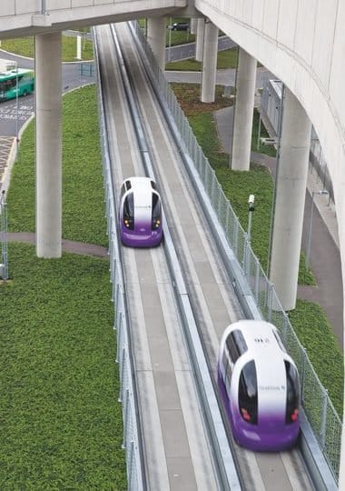
Heathrow Airport’s automated vehicle system. Photo credit: © Ultra Global Ltd, Heathrow Airport Limited
The second is automated vehicles, which did not have much visibility in 2008. In an article I authored for HuffPost in 2016, I wrote this: “the key to implementation of automated vehicles will be the use of our existing roads, a well-organized spoke-and-hub system connecting our business, shopping, entertainment, residential and transportation centers. To-date, automated vehicles haven’t been able to use public roads because unpredictable human drivers are using them. But that is about to change. Heathrow Airport began piloting an automated vehicle system in 2010, using pods designed by Ultra Global running on dedicated roads created by Arup. The system demonstrates how automated vehicles could be successfully used on dedicated roads where other traffic is not allowed.”
How will automated vehicles and rideshare services affect a future Grand Central Station, both in operation and in regards to financing? Will a system of automated pods, shuttles and buses, all powered by electric motors, be the future of our ground transportation system? What will that mean for what a Grand Central Station should look like? How will the need for rental cars, parking, and even traditional transit change as a result? NBC’s Today Show recently aired a piece where two travelers to Orlando, Florida, flew together and stayed in the same hotel, but one used a rideshare service from the airport and to various attractions and the other used a rental a car. In terms of both money and time, the rideshare was a better choice. What does this mean for not only future traveler choices, but also revenues to support a Grand Central Station and its design?
None of this diminishes the value of a Grand Central Station for San Diego. It only highlights the issues that need to be addressed from the very beginning of the process. What elements could potentially block the project? How can they be identified and addressed early on? Addressing the potential obstacles and a future not yet imagined by most decision makers and the public will create a pathway so an outstanding and imaginative project for the San Diego Region will not be scuttled because of obstacles like those listed above.
The values of a Grand Central Station will be significant, as was detailed in our airport sustainability report, “San Diego International Airport Expansion Sustainability Analysis.”
We commissioned the study from Malcolm Pirnie (now Arcadis) A 110-year-old international firm of engineers, scientists, and planners in conjunction with Sinclair Knight Merz (SKM), an Australian firm with experience working with airport operators in Australia, New Zealand and the UK to develop strategies for continued expansion and more sustainable operations.
The report provided an extensive analysis of regional transportation, greenhouse gases, criteria pollutant emissions, sustainability and green airport and green building opportunities for SDIA expansion using scenarios proposed in the airport master plan and our Lindbergh ITC concept.
The results were, and continue to be, compelling.
Regional Transportation
One of the more eye-opening results of our sustainability report was the realization of just how much airport traffic affects city streets. As can be seen in the graphic below, a number of the streets around the airport, those maintained by the City of San Diego, receive the majority of their traffic from the airport.
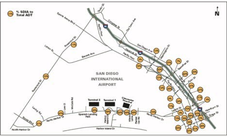
Airport operations already contribute a significant amount of traffic to City streets. The numbers in the circles represent the percentage of airport traffic by street segment. Image from San Diego International Airport Expansion Sustainability Analysis.
A representative sampling of roads with significant airport traffic included:
75% - North Harbor Drive west of Laurel Street
67% - Grape Street east of North Harbor Drive
76% - Hawthorn east of North Harbor Drive
70% - Laurel Street between Kettner Boulevard and North Harbor Drive
Even Rosecrans Street between Sports Arena Boulevard and Lytton Street received 12 percent of its traffic from the airport.
In addition to carrying a large percentage of airport traffic, these city streets are congested to unsatisfactory levels of service (LOS). The state of California’s transportation agency, Caltrans, defines these levels of service:
A – very short delays, (< 10 seconds)
B – short delays, (11 – 15 seconds)
C – minimal delays, (16 – 25 seconds)
D – minimal delays, (26 – 35 seconds)
E – Significant delays, (36 – 50 seconds)
F – Considerable delays, (>50 seconds)
Current (2005) Conditions. Under current (2005) conditions at the time our report was published, North Harbor Drive, Grape, Hawthorn and India streets were all at Level F.
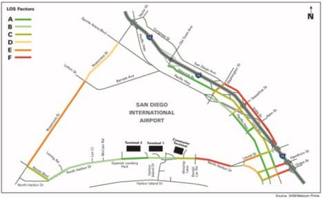
Image from San Diego International Airport Expansion Sustainability Analysis
Current conditions (2005) already showed significant congestion on streets servicing the airport. The legend in the upper left corner of each graph indicates level of service (LOS) ratings or congestion. Red is an unacceptable level of service, and bright green is the best, with shades of color in-between representing varying degrees of congestion.
2030 Conditions, Airport Preferred Alternative. Under the airport’s preferred alternatives in its 2008 master plan, traffic worsened throughout the area.
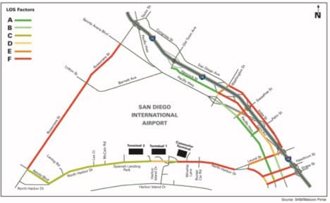
Image from San Diego International Airport Expansion Sustainability Analysis
By 2030, under the Airport Preferred Alternative, congestion has seriously impacted Harbor Drive, Hawthorn Street and Grape Street. Some street segments can be mitigated, but even with 10 lanes of traffic, portions of Harbor Drive would not be mitigable. Even with mitigation, Grape and Hawthorn streets could need up to six lanes of traffic to reach acceptable levels of congestion. Rosecrans Street’s level of service would still be F.
Lindbergh Intermodal Transportation Center 2030. Moving the terminals to the north side of the runway and creating a Grand Central Station dramatically improved traffic congestion on all streets except a short section of India Street north of Laurel Street.
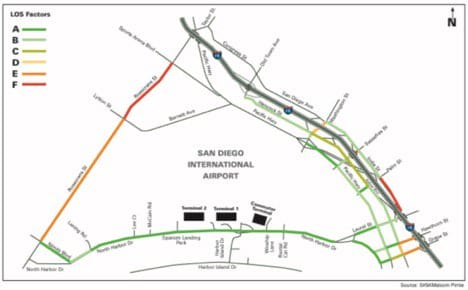
Image from San Diego International Airport Expansion Sustainability Analysis
The Lindbergh Intermodal Transportation Center concept would improve traffic congestion, particularly along the waterfront and in Little Italy neighborhoods. Depending on freeway off-ramp decisions, congestion values might be higher on streets immediately adjacent to the ITC. Rosecrans Street would have little or no airport traffic because of the Lindbergh ITC, but level of service would still be at LOS F or E because of background traffic.
Vehicle Miles Traveled (VMT). Reduction in the growth in vehicle miles traveled directly reduces greenhouse gases and emissions of criteria pollutants. The Lindbergh ITC would reduce growth of VMT by a factor of five over (2005) conditions, a reduction of 9.8%. The airport’s preferred alternative reduced growth in VMT by 1.9%. According to the report, “these reductions (and therefore, related emissions) would decrease most significantly in the residential neighborhoods and surface streets near the airport.” It should be noted, however, that these decreases in the growth of VMT come in the face of overall growth in traffic for all scenarios, including the ITC, because of projected additional demand for air travel.
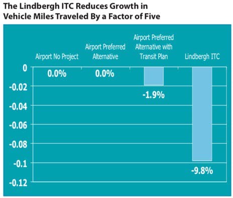
Image from San Diego International Airport Expansion Sustainability Analysis
Transit Share. By linking the transit options in one location adjacent to the airport, transit use increased by 5.2 percent. The airport preferred alternative increased transit share by 1.4%, the same as the no project alternative. Even with an airport transit plan in place, the preferred alternative only increases transit share by 3%.
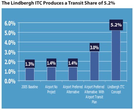
Image from San Diego International Airport Expansion Sustainability Analysis
In addition, the airport’s transit plan focused on buses, our plan focused on increasing use of rail options.
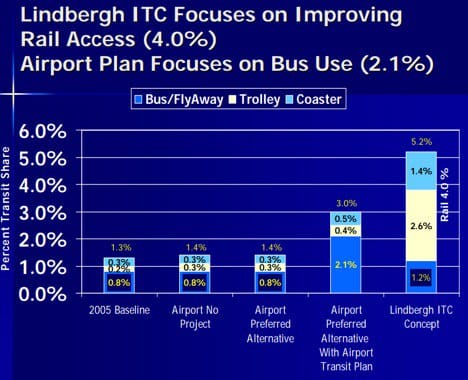
Image from San Diego International Airport Expansion Sustainability Analysis and LIndbergh ITC presentation materials.
Greenhouse Gas Emissions. An important driver for creating the Lindbergh ITC was the reduction in the growth of greenhouse gases. In parallel with the reduction in vehicle miles traveled and increase in transit share, the regional reductions in GHG under our plan was 9 percent. The airport preferred alternative created no measurable reductions.
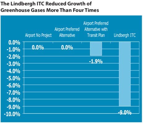
Image from San Diego International Airport Expansion Sustainability Analysis and LIndbergh ITC presentation materials.
Criteria Air Pollutants. As with greenhouse gases, the growth of criteria air pollutants was also decreased in parallel with reductions in VMT and increases in transit. These pollutants were reduced by 9.7% under our plan and not at all under the airport’s preferred alternative.
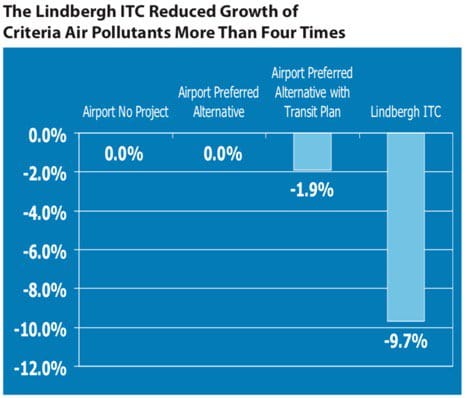
Image from San Diego International Airport Expansion Sustainability Analysis
Sustainability and Green Airport and Green Building Opportunities. Finally, the airport addressed opportunities to create a greener, more sustainable airport. Our plan far surpassed the airport’s preferred alternative as can be seen in the chart below.
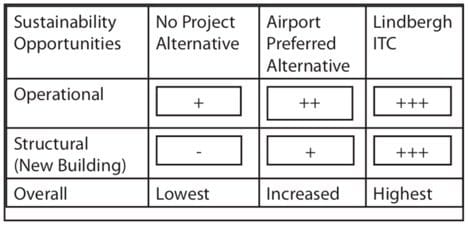
Image from San Diego International Airport Expansion Sustainability Analysis and LIndbergh ITC presentation materials.
The report suggested that the Lindbergh ITC created an opportunity to build a green airport that is a model of sustainability in energy use, water conservation, and waste reduction. The report identified practices put in place by other airports around the world that could be implemented in the ITC. The maximum benefit would be derived from creating new terminals. The report recommended the following actions in conjunction with the Lindbergh ITC would help create a model sustainable airport.
- Reuse and recycle materials from demolished buildings
- Incorporate LEED standards
- Use the most energy-efficient windows
- Install solar panels on Lindbergh ITC roof and airport terminal
- Use solar tubes to increase natural lighting and reduce electrical use
- Use the most up-to-date and energy efficient lighting systems and automatic sensors
- Create green roofs on the Lindbergh ITC and air terminals that minimize heat absorption and heat island effects
- Create rainwater collection systems on the Lindbergh ITC and the air terminals to allow reuse
- Recycle water for airport landscaping
- Integrate food handing and recycling with the potential for on-site composting on airport landscaping
- Newly designed traveler check-in and security queuing areas to provide efficiencies for airlines, TSA and travelers
- More efficiency for caterers and their access to planes
- Increased efficiency in baggage handling
- Increased cooperation and planning with airlines in planning technologies that assist in reducing airside impacts associated with airplanes:
- Towing planes to the runway
- Using landside plug-ins to avoid use of airplane auxiliary power units
- An underground fuel hydrant system to reduce the use of fuel trucks
To its credit, the airport has implemented many of these suggestions and many others as part of its widely promoted “Green Build.” In fact, SDIA has been a leader in developing sustainable practices on its current footprint, but it couldn’t implement “The Greenest Build,” which would have been to move the terminals to the north side of the runway in conjunction with a Grand Central Station.
The Land
Part of our analysis, independent of the sustainability report, included assessing the status of land use at the ITC site between Pacific Highway and I-5.
Other than airport property, 90 acres of land would have to be purchased, transferred from public ownership to the airport or an ITC entity, or obtained by eminent domain.
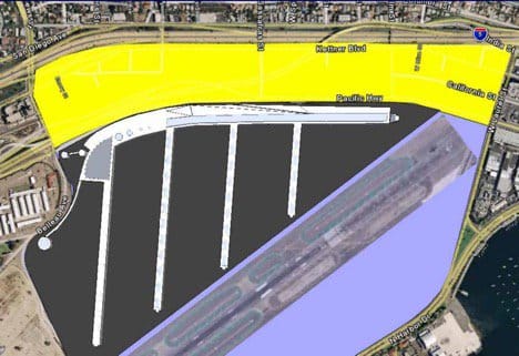
Image from Lindbergh ITC presentation materials
Ninety acres of land would have been needed to build the ITC north of Pacific Highway (area in yellow) as we imagined it.
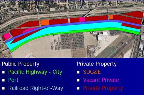
Image from and Lindbergh ITC presentation materials
Much of the 90 acres was already in public ownership or part of the transportation system. Even the Port, in informal discussions, was willing to consider relocating its iconic building.
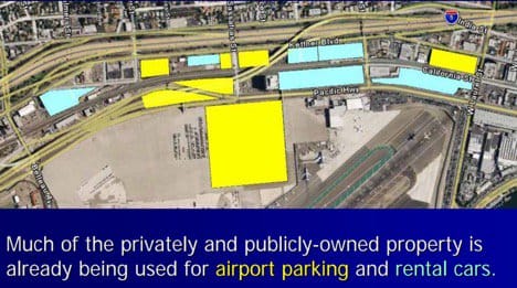
Image from and Lindbergh ITC presentation materials
The land we considered for the ITC already was being used for airport related activities.
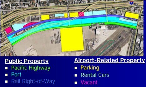
Image from and Lindbergh ITC presentation materials
In this view, it is obvious how much of the land could be aligned to ITC use. Only the uncolored parcels are either being used for non-airport use or are not publicly owned already.
We believed that our plan would have unified all the existing transportation coming into San Diego: air, ship, trolley, coaster, highway, rental car, flex car, bus, taxi and shuttles. We also thought it could catalyze future transportation opportunities: high speed rail, trolley expansion, a people mover and a water taxi – although we did not foresee ridesharing and automated vehicles. What does the Grand Central Station concept need to foresee?
A Previous Plan – Concept C
The Grand Central Station proposal is at least the third iteration of a similar concept. In the 2001 Airport Master Plan, an expansion option was considered called Concept C. This concept also imagined moving the terminals to the north side of the runway and showed how a second runway could be incorporated on the airport’s existing footprint. Like our concept, the Concept C plan utilized land between Pacific Highway and I-5 to unify passenger processing while linking with the region’s transportation options.
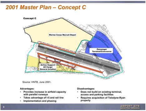
Image from San Diego International Airport 2001 Master Plan
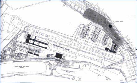
Image from SDIA Airport Master Plan
This view of Concept C in 2001 also imagined passenger processing connecting with regional transportation options on the north side of the runway between Pacific Highway and I-5 and shows how airport gates might be configured.
Conclusion
San Diegans, the state, the nation and the planet lost a chance to reduce the growth of transportation-related greenhouse gases and criteria pollutants in 2008 when the opportunity existed to move the terminals to the north side of the runway. In addition, the region lost the chance to relieve the communities around the airport of congestion imposed on those communities because city streets in the area are essentially airport access roads. Finally, the opportunity was lost to conveniently reach the airport by transit and to have a linking place, a Grand Central Station, to easily transfer from modes and routes, relieving the region of additional traffic congestion.
While it is too late to move the terminals to the north side of the runway, some of the benefits of the Lindbergh ITC could be regained by a Grand Central Station, whether at SPAWAR or our proposed Lindbergh ITC site.
Maybe we were ahead of our time. The City of San Diego didn’t have a legally binding Climate Action Plant in 2008. The state’s initiatives in that regard were still evolving following the passage of AB 32, the California Global Warming Solutions Act of 2006.
Hopefully, the time is right now. In the past, the region (and our proposal) unrealistically relied on the leadership of the airport to develop this community-wide solution, believing that was appropriate. As noted above, constraints on airport funding for projects not on airport property contributed to frustrating that hope. The airport’s willingness to fund Destination Lindbergh and share leadership of the ad hoc policy committee in conjunction with the City of San Diego and SANDAG, showed the airport’s good faith and interest in exploring the possibilities of linking the airport to regional transportation modes.
The current plan is being led by SANDAG, San Diego’s official regional planning agency. Let’s hope the region, under SANDAG’s leadership, will be able to meet the challenge of making San Diego’s Grand Central Station a reality.
I recognize that much has happened since 2008 and have not attempted to include those changes in the text above. the construction of the CONRAC (consolidated rental car facility) likely reduced congestion. Building the Terminal 2 garage likely didn’t. Long-term parking was moved to the Pacific Highway side of the runway, shuttling airport passengers to the terminals as they would from a Grand Central Station. This likely reduced traffic on Harbor Drive. Recently, short-term parking was eliminated from Pacific Highway and employee parking was moved from Harbor Drive to Pacific Highway, perhaps a wash in congestion relief.
Are the numbers from our sustainability report still accurate? Clearly a new study would modify them. However, they still give a sense of conditions and what was known in the 2007/2008 time period and what was projected for the future. Hopefuly, they can still be useful as a comparison to current conditions and any new projections for traffic, transit use, vehicle miles traveled, greenhouse gases and criteria pollutants in the future. I look forward to learning the current status and projections for traffic congestion and related impacts for both the SPAWAR and the ITC sites.
Finally, if there was a reason to prefer the ITC site over the SPAWAR site, it would simply be proximity, not only for air traveler convenience, but for the ability to annex any adjacent property needed to the airport and its master plan, potentially providing a pathway, however unlikely, to access airport funds under FAA rules.
In addition, in 2008 we were aware of potential for conflict between the Airport Master Plan and master planning for the Port of San Diego’s North Embarcadero. The Port envisions waterfront parks, walkability, bike paths and a green, visually stunning waterfront, yet the airport’s use of Harbor Drive and Grape and Hawthorn streets as access roads intrudes into this North Embarcadero vision. A strategy to meet the needs of both the airport and the Port will require a collaborative effort to meet both visions.
Because of the importance to the community, to transportation, and to efforts to address climate change, we can’t settle for less on the Grand Central Station project, no matter what site is chosen. The project should not be seen as just as a link to the airport. It must be seen as a place where all of San Diego transportation modes join, including the airport. Kudos to SANDAG for taking the lead and for Executive Director Hasan Ikhrata for a willingness to take on the challenges facing this most important endeavor.
In 2007, the Independent Voter Project commissioned a project to study and provide to decision makers an option for integrating San Diego’s ground transportation with the airport. We hired Nettleton Strategies to manage this project, and given the recent interest in developing a Grand Central Station near the airport that includes IVP’s suggested site as an option, we asked Carl Nettleton to recap what we learned from our work in 2007 and 2008.
______________________________________________________________________________
Carl Nettleton is an award-winning writer, acclaimed speaker, and a subject matter expert regarding water, climate, sustainability, the ocean, and binational U.S. Mexico affairs. For more than 25 years, Carl has played a major role in addressing large infrastructure-related regional issues including the airport, water, wastewater, and storm water. He operates Nettleton Strategies LLC, a trusted source of analysis and advice on issues at the forefront of public policy, business and the environment. Portions of this article are adapted from a chapter in a work-in-progress, “The Wolf’s Tail and the Mars Lander,” a book about environmental and economic policy and political conflict in America.